IT'S A GREAT WEEK TO CELEBRATE PUBLIC WORKS!
Blog by Emily Pierce, PLS, CFedS
After the heady celebrations of National Infrastructure Week, we’re sliding right into National Public Works Week. Ok, I’m being a bit silly here, but it is certainly true that things are looking up for our infrastructure and those involved in building and maintaining the structure that undergirds our modern way of life.

As someone who understands the importance of an accurate and solid foundation in public works, I’m happy that attention is being focused on what it takes to create livable communities – all the seemingly invisible things that hold everything together. Most of the time, no one thinks about public works and infrastructure until they don’t work right – like we recently saw in Texas with the power grid and now out east with the pipeline shut down. When disaster strikes, people recognize the essential nature of infrastructure and demand its restoration.
As surveyors, we have unique insight into what it really takes to create and maintain that infrastructure. In my neck of the woods, a lot of surveyors are involved in laying the groundwork for improving power transmission. Everyone knows that storms and overhead power lines don’t mix very well, so many power companies want to put their lines underground. They rely on surveyors to compile parcel information so that powerl ines can be moved underground. This pre-work is essential to making sure power lines are placed correctly within the ROW and the location is documented.
I’m not actively surveying, but I’m still involved with public works. Right now, I’m working with several municipalities and some private companies address a thorny problem. Public works administrators have to manage a lot of things, from roads to stormwater systems to parks to construction sites. A lot of them are using GIS-based asset management systems in the effort to create a digital twin of the existing infrastructure so that they can manage maintenance efforts, locate buried assets and so on.
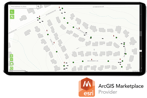
Unfortunately, these digital representations are often unconnected with reality, which negates their usefulness. That’s where Berntsen’s expertise comes in. We’ve developed a way to connect the physical asset to its digital record with RFID. Connected RFID™ means that when public works managers send a crew out to perform maintenance on assets, the crew can easily locate the physical asset AND update its digital record in real time.
Surveyors know the usefulness of being able to find a specific point in the field. That’s why we use GPS and magnetic locators. We understand the importance of both the computed (digital) location of something, as well as the significance of the monument or asset in the ground. When that ability is combined with access to its digital record in GIS, it can be a game-changer for public works managers.
Right now, I’m working on a couple of presentations that will be part of the American Public Works Association Conference in St. Louis this August. We’ll be presenting sessions on “Streamlining Stormwater Asset Management with RFID” and “RFID Connects Field Assets to the IoT”. If any of you are attending that conference, be sure to stop by!
In the meantime, just email me or contact us if you want a demo!