
Disaster response & resilience
A recent survey revealed that many people believe that natural disasters are more frequent and severe than in the past. It turns out that this observation is backed up by facts. According to the National Oceanic and Atmospheric Administration (NOAA), the frequency of natural disasters is increasing year-over-year. There were 28 weather and climate disasters in 2023, surpassing the previous record of 22 in 2020, tallying a price tag of at least $92.9 billion.
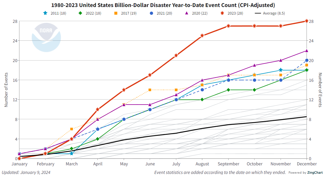
Month-by-month accumulation of billion-dollar disasters for each year on record. The colored lines represent the top 6 years for most billion-dollar disasters. All other years are colored light gray. NOAA image by NCEI.
A recent survey revealed that many people believe that natural disasters are more frequent and severe than in the past[1]. It turns out that this observation is backed up by facts. According to the National Oceanic and Atmospheric Administration (NOAA), the frequency of natural disasters is increasing year-over-year. There were 28 weather and climate disasters in 2023, surpassing the previous record of 22 in 2020, tallying a price tag of at least $92.9 billion.[2] These disasters include drought, flooding, hail, wildfires, hurricanes, tornados and other severe weather including winter storms.
When speaking of severity in terms of damage cost, some of the increase is simply because the cost of living has increased, the population has increased and there is more development in vulnerable areas. However, statistics adjusted for inflation show that the cost per capita of natural disasters has increased. In the early 2000s, the average 5-year disaster cost was $150; today that cost is more than $400[1] per person. That’s because billion-dollar disasters have become more frequent.
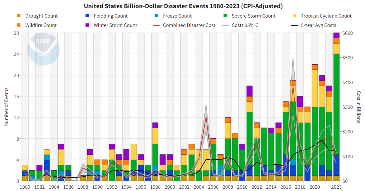
The cost per capita (see right y-axis in chart) is also rising for the U .S. as a whole meaning that the costs of the billion-dollar disasters is rising more sharply than general population growth.
Local impact
The aggregate view of how natural disasters impact the nation is important, but it’s more important to know how local governments and utilities are preparing for and responding to more frequent and severe natural disasters.
In most areas, people rely on their public works officials to prepare the community for natural disasters. Public works is:
…the combination of physical assets, management practices, policies, and personnel necessary for government to provide and sustain structures and services essential to the welfare and acceptable quality of life for its citizens*.
*According to the American Public Works Association, (APWA)

Studies are revealing
The above definition seems to cover just about everything in municipal government – including disaster preparedness and response. More and more resources and study is focused on managing disasters. Now, the language to describe these events has become more specific. For example, there’s a difference between a disaster and a catastrophe.
First Responders are expected to be seen at the site of any disaster – fire, police and medical services are continually training for worst-case scenarios. Another, less heralded member of this response team is the public works staff who are committed to protecting the nation’s vast public infrastructure and facilities. Public works plays a key role in Homeland Security by ensuring our essential infrastructure is safe from man-made and natural disasters.
According to the APWA:
As First Responders, public works professionals are responsible for many aspects of disaster response, including, and disposing of debris; restoring lifeline services to their communities; managing traffic and transportation for responders, victims, and the public; managing and coordinating municipal vehicles, equipment and manpower; and restoring the infrastructure well after the initial event. Public works is also integral in emergency planning, hardening and security of critical facilities, and ensuring a safe public water supply.[4]
Technology can help reduce the impact of natural disasters

Recovery Survey - Molly Holt, an Army Corps of Engineers infrastructure team civil engineer for Hurricane Ian recovery, conducts a rapid evaluation safety assessment at Fort Myers Beach, Fla., Oct. 19, 2022. Edited image. Original photo by Patrick Moes, Army Corps of Engineers.
Fortunately, technology is helping officials predict and then respond to natural disasters. The ability to analyze large amounts of data from satellites, drones, social media, help officials before, during and after events. AI, machine learning and cloud computing are helping to predict weather, earthquakes, and floods,[5]
Geographic Information Systems (GIS) is widely used by municipalities and are uniquely suited to help coordinate emergency response in real time. Location-based data gives officials situational awareness so that they can respond appropriately where help is needed most. This same platform helps municipalities assess damage after a natural disaster.
Berntsen has partnered with Esri’s ArcGIS to leverage RFID to mark infrastructure assets – an approach that can streamline response to disasters. GIS provides a digital map of all infrastructure assets, from buried gas lines to transformers. Unfortunately, in the case of some events, such as earthquakes and floods, these infrastructure assets may actually shift with the landscape, making maps less effective. That’s why some organizations are marking their assets with passive RFID tags. That way, any asset can be positively identified in the field with a quick RFID scan that will automatically link to its data in GIS. These RFID tags don’t require power or line of sight, making them particularly useful after widespread disasters.
Using RFID to help locate infrastructure after a natural disaster was first studied more than 10 years ago, and since that time, this technology has improved and been integrated into Esri’s data collection tools to better locate and verify assets, including assets that may have moved during natural disasters.
Thank you, public works officials
This week, public works officials from across the US and Canada will be meeting to learn about the latest technology and techniques that can make their communities more resilient at the upcoming APWA-PWX meeting in Atlanta. Throughout the year, public affairs officials collaborate locally and regionally to best prepare for and respond to natural disasters.
Here at Berntsen, we’re grateful for the hundreds of thousands of people who support our way of life through public works. We salute the first responders, police, fire, street maintenance, sanitation workers, GIS technicians, city administrators and planners and all the people that make our country a great place to live.
Footnotes:
[1] https://www.thezebra.com/resources/research/natural-disaster-statistics/
[3] https://udspace.udel.edu/server/api/core/bitstreams/7f8df691-a569-4374-bf43-a0c6b36c392c/content
[4] The Essential Role of Public Works in Emergency Management, APWA
[5] https://www.hcltech.com/trends-and-insights/10-technologies-reducing-impact-natural-disasters

It’s National Public Works Week
If you’ve taken a trip recently, you’ve probably noticed the construction – on roads, bridges, dams, airports, railways and other large projects – causing frustrating backups and bottlenecks. Unfortunately, this inconvenience is one of the costs for years of infrastructure neglect.

2021 Report Card GIS map from the American Society of Civil Engineers.
If you’ve taken a trip recently, you’ve probably noticed the construction – on roads, bridges, dams, airports, railways and other large projects – causing frustrating backups and bottlenecks. Unfortunately, this inconvenience is one of the costs for years of infrastructure neglect.
According to the Council on Foreign Relations, the U.S. generally lags behind its peers in the quality of its infrastructure – and its spending on infrastructure ranks toward the bottom among the Group of Twenty (G20) countries.[1] The recent infrastructure bill passed by Congress in 2021 should help reverse this trend, but it will be a while before the 40,000 projects now underway will be completed.

Graph from “The State of U.S. Infrastructure written by James McBride, Noah Berman, and Anshu Siripurapu from the Council on Foreign Relations.
Infrastructure spurs economic activity
A 2022 analysis by the World Bank reported that every public dollar invested in infrastructure led to $1.50 in resulting economic activity, with an even larger effect during a recession.[2]
Clearly, it’s worthwhile spending money on infrastructure, especially since it directly supports our $25 trillion dollar economy. Ironically, it is our state and local governments that spend the most money on infrastructure. In 2020, less than half of US public infrastructure and transportation funding was from the federal government.
Even with the dramatic increase in federal funding, many experts say that the US has a long way to go before the infrastructure deficit is resolved.
In the meantime, public works departments across the country are busy working on projects that have been delayed for years.
It’s National Public Works Week

Unified Command commences bridge wreckage removal for Key Bridge Response 2024.
Public works are essential to maintaining our quality of life – from first responders to water treatment to parks, public works are key to modern life. The recent bridge disaster in Baltimore highlights the importance of public works. The destruction of the Francis Scott Key bridge – which took five years and more than $110 million to build in the 1970s – took just six seconds to collapse after being hit by a cargo ship.[3] Tragically, six workers performing nighttime maintenance on the bridge died when the bridge collapsed. They were doing the necessary but often dangerous public works jobs that keep our country running.

Map shows alternate traffic routes to bypass the Francis Scott Key Bridge in Baltimore.
Infrastructure sustains the economy
Aside from the loss of life, the loss of infrastructure such as this bridge (that is blocking access to the port) is catastrophic for the local and regional economy. The Port of Baltimore processed 1.1 million containers of cargo in 2023, including 850,000 shipments of cards and light trucks[4]. The value of the goods that pass through the port every year is valued at about $80 billion. It’s the number one port for farm equipment; coal exports are also huge. 15,000 people work directly for the port, with another 140,000 whose work are indirectly dependent on the port.[5]
In addition to the ship traffic into and out of the port, between 30,000 and 35,000 vehicles drove across the 1.5 mile bridge every day. Clearly, the project to remove the wreckage and build a new bridge is a priority, and $60 million has already been approved to clear the wreckage[6] (that is now being blasted from the container ship[7]). Joe Kane, a fellow in Brookings Metro points out “. . . it’s somewhat unfortunate that it does take a disaster like this, as it does for a lot of infrastructure issues, for many people to recognize, quite honestly, the economic importance and just even just the importance to our daily lives of these facilities. I mean, it’s not really optional, right? [Whether] we invest in this stuff? You know, we all depend on these types of facilities whether we realize it or not.”[5]

Outdated infrastructure
Across the country, public works officials are working to not only update critical infrastructure, they are building for the future. Much of our infrastructure was built soon after World War II (such as our interstate highway system), and today’s world is very different -- there are more people, more demands on infrastructure and environmental threats have increased. New approaches are required – for example, deeper harbors are needed for the bigger ships that come to port, and bridges must be better protected if they are hit by these huge ships[8]. They must also be able to withstand stronger storms and be designed for quick repair.

Recovery Survey - Molly Holt, an Army Corps of Engineers infrastructure team civil engineer for Hurricane Ian recovery, conducts a rapid evaluation safety assessment at Fort Myers Beach, Fla., Oct. 19, 2022. Edited image. Original photo by Patrick Moes, Army Corps of Engineers.
Disaster mitigation
Not every community has a port, but nearly every community faces some type of potential disaster. It’s part of the mission of public works to plan for and to help mitigate disaster impact. Many communities are using GIS technology to map out their infrastructure assets. If disaster strikes, the same system can help managers dispatch the right workers to the right place for a targeted response. GIS can also help prevent disasters by detecting risk levels, providing early warning systems and evacuation planning.[9]

GIS also helps recovery from disasters, by providing a digital map of all infrastructure assets, from buried gas lines to transformers. Unfortunately, in the case of some events, such as earthquakes and floods, these infrastructure assets may actually shift with the landscape, making maps less effective. That’s why some organizations are marking their assets with passive RFID tags. That way, any asset can be positively identified in the field with a quick RFID scan that will automatically link to its data in GIS. These RFID tags don’t require power or line of sight, making them particularly useful after widespread disasters.
Thank you, public works staff!
Public works staff now can access technology that can make their jobs easier. This is especially important in disaster preparation and recovery. Public works staff have been recognized as first responders since 2003, and the National Incident Management System (NIMS) lists public works alongside police, fire and the public as essential for disaster response.[10]
Here at Berntsen, we’re grateful for the hundreds of thousands of people who support our way of life through public works. We salute the first responders, police, fire, street maintenance, sanitation workers, GIS technicians, city administrators and planners and all the people that make our country a great place to live.
Footnotes:
[1] https://www.cfr.org/backgrounder/state-us-infrastructure#chapter-title-0-4
[3] https://crsreports.congress.gov/product/pdf/IF/IF12619
[4] https://www.cnbc.com/2024/03/31/baltimore-bridge-collapse-a-national-economic-catastrophe.html
[5] https://www.brookings.edu/articles/economic-impact-of-the-baltimore-bridge-collapse/
[8] https://www.cbsnews.com/news/how-to-protect-bridges-from-ships-baltimore-key-bridge-collapse/
[10] https://www.apwa.org/resources/apwa-initiatives/public-works-first-responders/