
Marking and Mapping – Two Factor Verification for Underground Locating
It’s spring and construction is booming . . . hopefully with fewer actual “booms”, caused by utility strikes. Safe digging is something that’s near and dear to surveyors and any profession that involves excavation. As I mentioned in my last blog, preventable utility strikes cost at least $60 billion annually, not to mention the loss of life and life-altering injuries that can occur.
Blog by Emily Pierce, PLS, CFedS
It’s spring and construction is booming . . . hopefully with fewer actual “booms”, caused by utility strikes. Safe digging is something that’s near and dear to surveyors and any profession that involves excavation. As I mentioned in my last blog, preventable utility strikes cost at least $60 billion annually, not to mention the loss of life and life-altering injuries that can occur.
Geographic Information Systems (GIS)
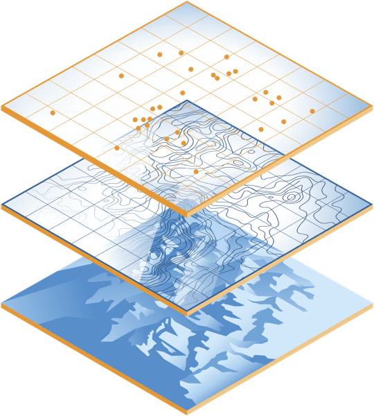
GIS has emerged as a leading approach to managing utility assets and will become an essential tool for subsurface utility management. But regardless of how accurate GIS maps become, there will always be the need to validate the digital representation of the underground assets depicted in the maps with high quality in-field marking products. Mapping and marking is required.
In today’s world, this is called ‘two-factor’ verification and it is used in solutions like Uber (mobile map coupled with driver verification on arrival), online banking (text to phone to validate your account ownerships you) and your doctor’s office (“please tell me your name and date of birth”).
Surveyors have practiced this for years by using maps and then relying on Berntsen survey markers in the field. Two-factor verification drives safety, reduces errors in identification, and improves operational performance. There is no industry with greater need for two-factor verification than underground locating.
Technology to the Rescue
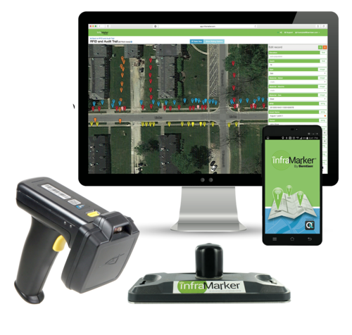
It is this two-factor verification that Berntsen has been working on with its InfraMarker RFID underground locating solutions. Tying an underground RFID asset identifier to a GIS delivers the best of both worlds – an accurate map with in-field verification.
I can’t help but think of the impact Connected RFID could have on preventing utility strikes if it was widely used. An RFID underground marker has a unique identifier tied to a GIS record so a field worker can identify the asset or particular location – not simply type of utility – before excavating. And RFID is utility agnostic, so the same locating and identification process works for water, gas, electric, or fiber.
We use two-factor verification to make sure we don’t get into the wrong Uber. Why can’t we take the same two-factor approach to make sure that we have safer underground digging?
Questions? Let us know!

MAGNETIC RFID SOLUTION
Utility marking is very effective at drawing attention to underground assets. In residential areas, marking can resemble graffiti – and raise concerns about what kind of disruption is sure to follow the marking.
The Case For Magnetic RFID As A Low Impact Marking Solution
Utility marking is very effective at drawing attention to underground assets. In residential areas, marking can resemble graffiti – and raise concerns about what kind of disruption is sure to follow the marking.
In response to groups of vocal critics to over-marking, state legislators have begun looking for smarter solutions. As a result, new techniques that reduce visible marking (low impact marking) are welcomed.
How utility companies can make low impact marking a priority
Existing ticketing systems often lead contractors to select a larger area for marking than is actually needed.
An improvement would require requestors, One Calls, and locators to share highly detailed specifics about an area in question, which would reduce the size of area requiring marking.
A permanent solution to the problem would be a locating and marking method that is precise and specific.
RFID provides a long-term permanent locating and marking solution
Radio Frequency Identification (RFID) systems, like the InfraMarker, provide a permanent solution for faster locating and more accurate marking.
Passively powered, durable RFID tags are placed underground stored with access to digital information about the underground assets. This RFID tags can be found and read using a handheld digital reader. This makes it possible to apply even more precise aboveground markings while reducing the visible impact of a project during the planning and preparation process. The robust durability of these tags allow them to function for years at a time even in areas where weather would otherwise degrade or deteriorate other markings.
In conjunction with more complete communication procedures between infrastructure owners, RFID markers offer utility engineers a low impact, accurate and permanent marking solution.
If you’re looking to solve the problem of over marking and improve the accuracy and efficiency of your buried asset location projects, look to RFID systems, like the InfraMarker, for an innovative solution.