HOW UNDERGROUND RFID MARKING IS CHANGING THE UTILITIES INDUSTRY
You would think that with all of the technology available today, we’d be able to see what’s underground almost as well as we see what’s above ground. Unfortunately, that’s not the case - underground utility locating remains an issue.

Today, excavators rely on locators to come and find each utility and mark it with a flag before they dig – at least most of the time. In 2018, the single most frequent reason for underground utilities being mistakenly hit during excavation was “Notification NOT made” – meaning that locators were not used before excavation began.
However, if locators are used, it doesn’t mean that they provide exact information – the same report states that 24 percent of accidental utility strikes were due to Locating Issues.
RFID to the rescue
A reliable way to locate buried utilities and instantly know key information about that utility already exists -- based on proven RFID technology. Radio Frequency Identification has been used for years to track items without having to visually confirm them – typical uses are the toll-booth passes that are read remotely when we pass through a toll, or markers on library books that are scanned when we check them out.
RFID tags are ideal for underground utility marking because they are passive (don’t require a battery), have a unique ID as well as a small amount of memory that can contain data such as the utility type and owner. They are durable and can include a magnet to increase the precision of underground locating. Today there is a solution based on RFID markers that is already being used by some utilities.
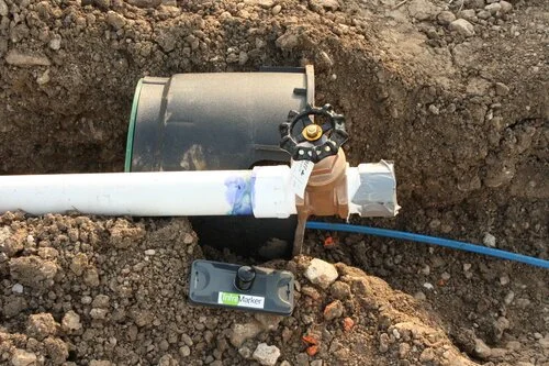
This system is called InfraMarker®, and it’s designed to provide accurate information about assets, below or even above ground. InfraMarker RFID tags are placed on or near the asset. Once accessed with an RFID reader, the latitude, longitude, and unique ID are written to the tag. Then additional information, such as the type of asset and owner are added through software on a smart phone connected to the reader via Bluetooth.
InfraMarker RFID marker and water utility before burial.
Imagine the time and money that could be saved if underground utilities were marked with RFID tags. Excavators could precisely locate underground utilities, and even know what type(s) of utility was below.
Connected infrastructure
With millions of miles of underground piping across the United States, it stands to reason that identifying the unique characteristics of a single asset may be a challenge.
That’s where connected infrastructure can make a huge difference. Asset management software that is now used by many municipalities and utilities can pull the data from each RFID marker and associate that with data in the application – and plot this on a digital map. This data can be shared between utilities, so that location information of water lines, gas lines, telecom lines and fiber optic cables could be shared in a common file format.
Not only would this save time for utilities, it would prevent the estimated $50 billion annual cost of excavation utility strikes.
Contact us to set up a demo to see how the simple, easy-to-use and setup InfraMarker system can save time, money and provide the data you need with the accuracy you require.