SURVEYORS EMBRACE NEW TECHNOLOGY

Main Objective
Correspondingly, 27 percent of surveyors cite building / construction / engineering design as their firm’s primary business.
According to an article in Point of Beginning citing a recent study, the surveying profession is undergoing some important changes.
The past five years have seen a notable drop in boundary surveys as the primary surveying activity -- from 35 percent in 2015 to just 15 percent in 2020. Correspondingly, 27 percent of surveyors cite building / construction / engineering design as their firm’s primary business - up from just nine percent in 2015. Clearly, more and more surveying firms rely on the construction industry as their primary activity.
Additionally, with the needed investment in upgrading existing infrastructure nationwide, we will likely see this increase even more in the future.
A wave of new technology
As construction continues to become a bigger part of the business, surveyors are not only using new technology, they are becoming acquainted with new technologies used by their customers. For example, many construction and engineering firms contract with municipalities that use Geographic Information Systems (GIS) to map and track infrastructure assets. Asset location is represented on a digital map, which is very useful for centralized planning and administration of resources.
Unfortunately, the benefits of these digital asset mapping applications often do not seamlessly transfer to the field. Ideally, the digital map would guide field workers to the exact asset that has been assigned for inspection and maintenance. In practice, field workers discover that the physical assets don’t correspond to the digital location, or there are several assets in close proximity, making precise identification impossible. If the assets are buried, then each time an asset needs to be accessed, a time-consuming and costly locating process must be completed.
InfraMarker RFID tag marking an underground pipeline
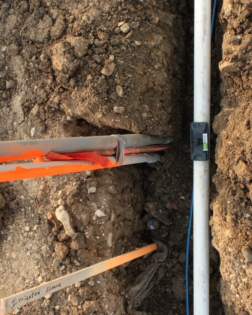
InfraMarker RFID tag marking an underground pipeline
This is where the work of surveyors can be of great benefit to organizations that use GIS-based asset mapping software. Asset management software is not based on survey-grade precision, which leads to ongoing locating problems in the future. Surveyors have the ability to generate the precise physical location data that is inherently of tremendous benefit to municipal or utility asset management programs.
A crucial reason why precise location information is so valuable to utilities is the prevalence of excavation utility strikes. The Common Ground Alliance found that in 2018, the single most frequent reason for underground utilities being mistakenly hit during excavation was “Notification NOT made” – meaning that locators were not used before excavation began.
However, if locators are used, it doesn’t mean that they provide exact information – the same report states that 24 percent of accidental utility strikes were due to Locating Issues.
That data illustrates the fact that existing utility locating methods are not sufficient. However, surveyors have the data and can offer a way to link specific, verified physical location to digital asset management data.
Surveyors can provide value-add to customers
The key is RFID. By combining RFID markers and simple smart phone applications, surveyors can provide an adaptable way to tie physical location with a customer’s GIS system. This offers a tremendous benefit to utilities because RFID can be tied into their digital asset system and provide verifiable asset location and data.
The InfraMarker system provides a turnkey way to quickly mark infrastructure assets.

InfraMarker RFID-tagged utility assets displayed on a cell phone screen.
InfraMarker RFID-tagged utility assets displayed on a cell phone screen.
For example, when surveyors mark the path for a new municipal water pipeline, RFID markers can be placed at key points, above or below ground. Each InfraMarker tag has a unique ID that can be immediately pulled into the GIS/Asset Management system, or it can be added to the GIS / asset management system later. InfraMarker tags last for decades, are passive (only activated when pinged by and RFID reader) and don’t require batteries so there’s no maintenance.
With InfraMarker, surveyors can offer lasting benefit to municipal and utility customers by anticipating their need to accurately digitize physical location.