
National 811 Day - little known but important!
It’s National 811 Day – a very important, but little-known commemoration. Anyone who is planning to disturb the ground should call this number before digging or excavating – or go to call811.com and connect online. Once you provide the area of excavation, locators will come out and mark the location of buried gas pipes, water lines, power cables and other underground utilities.

It’s National 811 Day – a very important, but little-known commemoration. Anyone who is planning to disturb the ground should call this number before digging or excavating – or go to call811.com and connect online. Once you provide the area of excavation, locators will come out and mark the location of buried gas pipes, water lines, power cables and other underground utilities.
This call can save your (or someone else’s) life. According to the Pipeline and Hazardous Materials Safety Administration (PHMSA), ruptured gas distribution systems have killed 12 people already this year. Since 2005, 225 people have died due to damages to gas distribution systems, with total damages to public and industry property of nearly $8.5 billion*. These are the statistics for the gas distribution industry alone.
For firms that are excavating every day, the need to “Know what’s below” is essential for safe operations.
The 2020 DIRT Report (Damage Information Reporting Tool) provides a more comprehensive picture of damages caused by all types of underground utility strikes – though the reporting is voluntary, not mandatory. The Common Ground Alliance (CGA) estimates that utility strikes result in $30 billion of direct and indirect costs every year. The most common root cause listed for these utility strikes was “failure to notify” (they didn’t call 811) before excavation.
The top five root causes of damage (70% of all reported damages):

No 811 call
No test hole dug for verification (pothole)
Facility marked inaccurately due to abandoned facility
Facility not marked due to excavator error
Excavator failed to maintain clearance for verifying marks
The truth is that no one knows how much damage results from excavation errors. In many sectors, there are no legal requirements for reporting utility strikes. Although a growing number of companies are voluntarily reporting, the data provides a very incomplete picture.
Until uniform processes and regulations are developed for marking and managing underground utilities, many utilities, construction companies and data centers are leveraging technology to “know what’s below”.
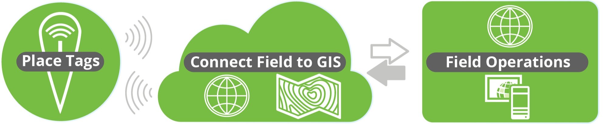
Geographic Information Systems (GIS) + Radio Frequency Identification (RFID)

GIS is a game-changing technology that is seeing explosive growth in many sectors, because it allows users to visualize data spatially. Passive RFID is the fastest growing identification technology and is also incredibly versatile – it provides a unique ID that can be tied to any type of data.
The convergence of these two technologies is fueling a new approach to managing utilities, called InfraMarker Connected RFID. GIS provides the maps, and InfraMarker RFID provides the location and asset verification essential to repair and maintenance crews in the field.
RFID delivers a direct connection between the buried asset and the geospatial map that is being used to locate the asset. Geospatial data is very good at visualizing an underground utility, but these visualizations don’t always provide the accuracy that is required in the real world, where a utility strike could result in a project delay (or disaster).
RFID provides field crews the two-factor verification that proves the identity and location of the scanned asset – even below ground. Esri’s Survey123 and Field Maps field data collection apps incorporate this highly accurate data into existing workflows. It is a game-changer for installation and maintenance crews, because now they can “know what’s below”.
How it works
It’s simple – an RFID tag is affixed on or near an asset (above or below ground). Each RFID tag has a unique ID that is linked to that asset’s record in GIS. Once linked, a field technician can scan a tag and automatically load that asset’s specific record for updating. No need for a line of sight with RFID, so this makes InfraMarker perfect for underground utilities.
The advantage of InfraMarker RFID is the accuracy it delivers to help utilities better manage their infrastructure assets. A value-add is that this data could also help prevent excavation strikes, helping everyone “Know what’s below”.
Until every buried utility is marked with InfraMarker RFID, it’s essential to call 811 before excavation – it can be a matter of life and death!
Give InfraMarker a try with our new Starter Kit!
Interested? Contact - info@inframarker.com

IT'S NATIONAL 811 DAY!
Today is National 811 Day – we are reminded to call 811 (or visit call811.com) before digging – in our yards or at a construction site. This simple reminder has saved lives and repair costs by preventing accidental damage to power lines, gas lines and other buried utilities during excavation.
A Blog by Emily Pierce, PLS, CFedS

“Notification NOT Made” was the single greatest root cause, selected for 23% of damages submitted. Although we continue to make progress, this root cause has hovered around 25% for the past six years.
“Notification NOT Made” was the single greatest root cause, selected for 23% of damages submitted. Although we continue to make progress, this root cause has hovered around 25% for the past six years.
Today is National 811 Day – we are reminded to call 811 (or visit call811.com) before digging – in our yards or at a construction site. This simple reminder has saved lives and repair costs by preventing accidental damage to power lines, gas lines and other buried utilities during excavation.
While we know that 811 has some inefficiencies, it is the best first line of defense for damage prevention for a property owner and the utility. Without proper locating subsurface utilities before excavation, the results can be costly.
Unfortunately, according to the latest DIRT Report (Damage Information Reporting Tool), the most frequent root cause of excavation damage was “failure to notify the one call center.” This cause of excavation damage is the most preventable. It’s also free for the reporter, so it’s also the most cost effective.
The cost estimate of not making the call to 811 is just that – an estimate. The United States lacks a requirement to report excavation incidents, so no one really has the data. Likewise, most states have a one-call center that’s funded and run by the utility partners themselves. Tracking excavation incidents across the board may not be compiled completely, or done on an individual utility company basis and not shared publicly. However, the Common Ground Alliance (CGA) has a reporting system that incorporates both voluntary and required submissions that offers a look into the root cause excavation damages.
It’s interesting to have a look at what it costs not to locate underground utilities.
According to a recent white paper by Geoff Zeiss and Dr. Sakuran Shinoaki, the cost (direct and indirect) of utility damage in the U.S. is $50-100 billion annually. The range is so broad because we don’t have a required or comprehensive reporting system. We actually don’t know how many excavating accidents happen and what they cost.
The paper goes on to present examples of utilities using mapping / modeling technologies to accurately model underground infrastructure. Recent advances in technology mean that ground penetrating radar and LiDAR can be used by surveyors to effectively capture underground infrastructure. When combined with GIS and other emerging technologies, accurate images of buried utilities could save billions of dollars annually and prevent loss of life.
Why isn’t more being done to accurately map buried infrastructure?
“IT HAS BEEN ARGUED THAT LIABILITIES MAY BE THE SINGLE MOST IMPORTANT KEY TO IMPROVING THE QUALITY OF LOCATION INFORMATION ABOUT UNDERGROUND INFRASTRUCTURE.”
The most interesting paragraph in this paper points to the reason why no coordinated effort exists to create an accurate and comprehensive reporting system. “It has been argued that liabilities may be the single most important key to improving the quality of location information about underground infrastructure.” I assume this means that if accurate information exists, then it might actually increase the financial risk of those involved in an excavation accident. This is disheartening as the cost paid isn’t always financial. There have been lives lost and injuries sustained, which carries a bigger burden than just money.
However, there is hope, as “some jurisdictions are implementing policies for shared liabilities to motivate all stakeholders to become involved in capturing and sharing better data about underground infrastructure to reduce risk.”
Additionally, I’ve spent the last few years lobbying on Capitol Hill with other members of the National Society of Professional Surveyors (NSPS) for the importance of accurate geospatial data for infrastructure projects. NSPS has taken a very active role with the importance of accurate geospatial data to be required for all infrastructure projects, including the physical framework of transportation, energy, communications, water supply, and other systems.
Opportunity for surveyors
Fortunately, industry-wide, there is a trend toward acknowledging the need for accurate underground infrastructure data and organizations are adopting new technologies to conduct underground surveys. A number of organizations are encouraging surveyors to become qualified in these new technologies and learn how to apply them in underground surveys. Along with GIS, LiDAR and GPR, other tools are making the job of underground surveying much easier. For example, an existing technology is now being used to tie physical assets to the data in GIS. For the past decade, Berntsen has been developing RFID to work with existing GIS platforms. The InfraMarker RFID solution is now being used to mark assets in the field and tie that specific location to the asset record in GIS. That means that with a simple RFID scan, a surveyor or field technician can identify each specific asset and access its record in the field, update the information and have that data instantly available in the GIS, accessible for locating, tracking, maintenance scheduling, planning and more.
So what needs to change?
Well, I think we all have a hand to play.

First, property owners have the responsibility to call 811. This ensures that first line of defense and reduces their risk of liability if something is damaged.
Then, utility locators have the responsibility to find ways to improve the speed and accuracy of locating. This likely includes increasing staff and resources so that the right people are available for quick marking turnaround.
Additionally, utility owners have the responsibility to invest in safety practices and technology that increases the accuracy of asset mapping/locating. This is an important step especially during the installation of new underground utilities. Accurate marking and mapping will protect infrastructure investments in the future. Surveyors are the key component to providing that accurate information to utilities.
It’s 811, and a great day to be a surveyor! We have the opportunity to make the world a better and safer place. I’m looking forward to helping the world “know what’s below.”