National 811 Day - little known but important!

It’s National 811 Day – a very important, but little-known commemoration. Anyone who is planning to disturb the ground should call this number before digging or excavating – or go to call811.com and connect online. Once you provide the area of excavation, locators will come out and mark the location of buried gas pipes, water lines, power cables and other underground utilities.
This call can save your (or someone else’s) life. According to the Pipeline and Hazardous Materials Safety Administration (PHMSA), ruptured gas distribution systems have killed 12 people already this year. Since 2005, 225 people have died due to damages to gas distribution systems, with total damages to public and industry property of nearly $8.5 billion*. These are the statistics for the gas distribution industry alone.
For firms that are excavating every day, the need to “Know what’s below” is essential for safe operations.
The 2020 DIRT Report (Damage Information Reporting Tool) provides a more comprehensive picture of damages caused by all types of underground utility strikes – though the reporting is voluntary, not mandatory. The Common Ground Alliance (CGA) estimates that utility strikes result in $30 billion of direct and indirect costs every year. The most common root cause listed for these utility strikes was “failure to notify” (they didn’t call 811) before excavation.
The top five root causes of damage (70% of all reported damages):

No 811 call
No test hole dug for verification (pothole)
Facility marked inaccurately due to abandoned facility
Facility not marked due to excavator error
Excavator failed to maintain clearance for verifying marks
The truth is that no one knows how much damage results from excavation errors. In many sectors, there are no legal requirements for reporting utility strikes. Although a growing number of companies are voluntarily reporting, the data provides a very incomplete picture.
Until uniform processes and regulations are developed for marking and managing underground utilities, many utilities, construction companies and data centers are leveraging technology to “know what’s below”.
Geographic Information Systems (GIS) + Radio Frequency Identification (RFID)

GIS is a game-changing technology that is seeing explosive growth in many sectors, because it allows users to visualize data spatially. Passive RFID is the fastest growing identification technology and is also incredibly versatile – it provides a unique ID that can be tied to any type of data.
The convergence of these two technologies is fueling a new approach to managing utilities, called InfraMarker Connected RFID. GIS provides the maps, and InfraMarker RFID provides the location and asset verification essential to repair and maintenance crews in the field.
RFID delivers a direct connection between the buried asset and the geospatial map that is being used to locate the asset. Geospatial data is very good at visualizing an underground utility, but these visualizations don’t always provide the accuracy that is required in the real world, where a utility strike could result in a project delay (or disaster).
RFID provides field crews the two-factor verification that proves the identity and location of the scanned asset – even below ground. Esri’s Survey123 and Field Maps field data collection apps incorporate this highly accurate data into existing workflows. It is a game-changer for installation and maintenance crews, because now they can “know what’s below”.
How it works
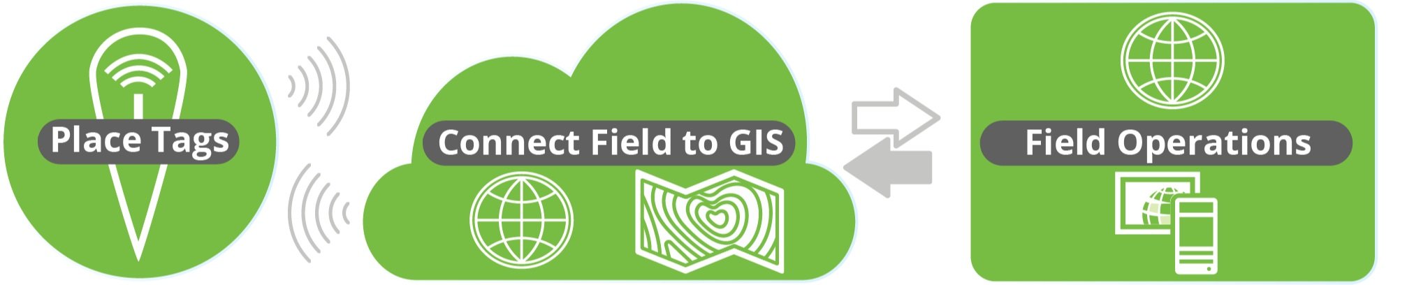
It’s simple – an RFID tag is affixed on or near an asset (above or below ground). Each RFID tag has a unique ID that is linked to that asset’s record in GIS. Once linked, a field technician can scan a tag and automatically load that asset’s specific record for updating. No need for a line of sight with RFID, so this makes InfraMarker perfect for underground utilities.
The advantage of InfraMarker RFID is the accuracy it delivers to help utilities better manage their infrastructure assets. A value-add is that this data could also help prevent excavation strikes, helping everyone “Know what’s below”.
Until every buried utility is marked with InfraMarker RFID, it’s essential to call 811 before excavation – it can be a matter of life and death!
Give InfraMarker a try with our new Starter Kit!
Interested? Contact - info@inframarker.com