
National 811 Day - little known but important!
It’s National 811 Day – a very important, but little-known commemoration. Anyone who is planning to disturb the ground should call this number before digging or excavating – or go to call811.com and connect online. Once you provide the area of excavation, locators will come out and mark the location of buried gas pipes, water lines, power cables and other underground utilities.

It’s National 811 Day – a very important, but little-known commemoration. Anyone who is planning to disturb the ground should call this number before digging or excavating – or go to call811.com and connect online. Once you provide the area of excavation, locators will come out and mark the location of buried gas pipes, water lines, power cables and other underground utilities.
This call can save your (or someone else’s) life. According to the Pipeline and Hazardous Materials Safety Administration (PHMSA), ruptured gas distribution systems have killed 12 people already this year. Since 2005, 225 people have died due to damages to gas distribution systems, with total damages to public and industry property of nearly $8.5 billion*. These are the statistics for the gas distribution industry alone.
For firms that are excavating every day, the need to “Know what’s below” is essential for safe operations.
The 2020 DIRT Report (Damage Information Reporting Tool) provides a more comprehensive picture of damages caused by all types of underground utility strikes – though the reporting is voluntary, not mandatory. The Common Ground Alliance (CGA) estimates that utility strikes result in $30 billion of direct and indirect costs every year. The most common root cause listed for these utility strikes was “failure to notify” (they didn’t call 811) before excavation.
The top five root causes of damage (70% of all reported damages):

No 811 call
No test hole dug for verification (pothole)
Facility marked inaccurately due to abandoned facility
Facility not marked due to excavator error
Excavator failed to maintain clearance for verifying marks
The truth is that no one knows how much damage results from excavation errors. In many sectors, there are no legal requirements for reporting utility strikes. Although a growing number of companies are voluntarily reporting, the data provides a very incomplete picture.
Until uniform processes and regulations are developed for marking and managing underground utilities, many utilities, construction companies and data centers are leveraging technology to “know what’s below”.
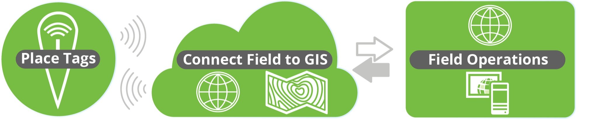
Geographic Information Systems (GIS) + Radio Frequency Identification (RFID)

GIS is a game-changing technology that is seeing explosive growth in many sectors, because it allows users to visualize data spatially. Passive RFID is the fastest growing identification technology and is also incredibly versatile – it provides a unique ID that can be tied to any type of data.
The convergence of these two technologies is fueling a new approach to managing utilities, called InfraMarker Connected RFID. GIS provides the maps, and InfraMarker RFID provides the location and asset verification essential to repair and maintenance crews in the field.
RFID delivers a direct connection between the buried asset and the geospatial map that is being used to locate the asset. Geospatial data is very good at visualizing an underground utility, but these visualizations don’t always provide the accuracy that is required in the real world, where a utility strike could result in a project delay (or disaster).
RFID provides field crews the two-factor verification that proves the identity and location of the scanned asset – even below ground. Esri’s Survey123 and Field Maps field data collection apps incorporate this highly accurate data into existing workflows. It is a game-changer for installation and maintenance crews, because now they can “know what’s below”.
How it works
It’s simple – an RFID tag is affixed on or near an asset (above or below ground). Each RFID tag has a unique ID that is linked to that asset’s record in GIS. Once linked, a field technician can scan a tag and automatically load that asset’s specific record for updating. No need for a line of sight with RFID, so this makes InfraMarker perfect for underground utilities.
The advantage of InfraMarker RFID is the accuracy it delivers to help utilities better manage their infrastructure assets. A value-add is that this data could also help prevent excavation strikes, helping everyone “Know what’s below”.
Until every buried utility is marked with InfraMarker RFID, it’s essential to call 811 before excavation – it can be a matter of life and death!
Give InfraMarker a try with our new Starter Kit!
Interested? Contact - info@inframarker.com

It’s Safe Digging Month - for good reason
As surveyors intimately understand, it’s very important to know what’s below. Your life could depend on it. National Safe Digging Month was created in 2008 by the Common Ground Alliance (CGA) to bring visibility to protecting workers, utilities and the public by working to prevent utility strikes during excavation. This group is comprised of companies and individuals in every facet of the underground utility industry, including Berntsen.

Blog by Emily Pierce, PLS, CFedS
As anyone involved in construction intimately understands, it’s very important to know what’s below. Your life could depend on it. National Safe Digging Month was created in 2008 by the Common Ground Alliance (CGA) to bring visibility to protecting workers, utilities and the public by working to prevent utility strikes during excavation. This group is comprised of companies and individuals in every facet of the underground utility industry, including Berntsen.
It’s interesting to note that although utility strikes are incredibly damaging and expensive (costing an estimated $30 billion annually in societal costs that include direct [facility repair] and indirect [property damage, medical expenses, business closures, etc.*]), there is no nationwide approach to marking, mapping and locating underground utilities. There’s also no requirement to report excavation damages to any centralized clearinghouse, except for the gas industry that reports major incidents to the Pipeline and Hazardous Materials Safety Administration (PHMSA). That’s why the CGA has developed a voluntary process for reporting strikes and damages.
The organization’s latest report presents the data of this voluntary reporting (and data from the PHMSA) in a very thorough way that looks at every aspect of utility strikes. They’ve found that “year over year, hundreds of thousands of damages occur, and most of them can be attributed to the same handful of persistent root causes.**” With the recent, massive investment in infrastructure, the overall trend of rising damages will likely continue.
The latest Damage Information Report Tool (DIRT) Report (from 2020 data reported in 2021) reveals some interesting information.

Figure 8 above shows the same information for 2020 only. Beginning in 2019 and continuing in 2020, the “big three” root cause groups – No Locate Request, Excavating Issues and Locating Issues – are approximately equal.
U.S. damages were down by about 12% in 2020 vs. 2019, likely due to the initial pandemic response that slowed the trend towards more construction projects. An analysis shows that even though the numbers of reported incidents were down, the same root causes persisted. Twenty-six root causes are tracked year-over-year and five of these account for 70% of the damage events. These five are:
Failure to notify the one call center/811 (the largest root cause of damages)
Excavator dug prior to verifying marks by test-hole (pothole)
Failure to maintain clearance
Abandoned facilities
Locator error
It’s pretty clear that lack of due diligence is behind many of the strikes. Construction projects often have pretty tight deadlines and perhaps field operators don’t feel they have time to call 811 (or maybe they don’t even know 811 is available). Even if a locator has been called, there’s no guarantee that the locator has accurately marked the underground facilities.
Technology to the rescue!

It doesn’t seem like this issue should be impossible to resolve – with today’s technology, solutions are available. Berntsen’s InfraMarker Connected RFID is a solution that could make a huge impact on reducing utility strikes, and it’s already being used in by pipeline companies and in data centers to mark underground utilities. It uses RFID and middleware to tie physical assets to data in Esri’s ArcGIS using Field Maps or Survey123.
As more and more utilities and municipalities adopt GIS, Connected RFID is available to verify location and precisely identify what facilities and conflicts exist underground before excavation. RFID can be read through soil, asphalt and concrete, so anything marked can be located and identified, simply by scanning the RFID marker and accessing the record through Esri’s data collection tools. Data can be shared between utilities, making this essential information available to all.
As more and more infrastructure projects get underway, it’s more important than ever to prevent damaging utility strikes. Connected RFID is leading the way in future-enabling connectivity of any underground (or above ground) asset.
Questions? Contact us.