
GIS + RFID = SUE Enhancement
Subsurface Utility Engineering (SUE) that leverages Geographic Information Systems (GIS) and Radio Frequency Identification (RFID) deliver substantial benefits in the management and protection of underground assets.
Subsurface Utility Engineering (SUE) that leverages Geographic Information Systems (GIS) and Radio Frequency Identification (RFID) deliver substantial benefits in the management and protection of underground assets.
Both GIS and RFID are rapidly-growing, powerful technologies that are used across a wide spectrum of industries, from manufacturing to agriculture to SUE.

When used together, GIS and RFID deliver accurate, verified information about any type of asset – above or below ground. This is particularly compelling for re-locating buried assets before excavation. It’s essential to know what’s below, and scanning the RFID buried asset tag provides authentication of its data in GIS.
RFID is a simple and durable technology, ideal for pairing with GIS. RFID tags consist of a microchip and antenna. Basic information, such as the asset’s location, identity and owner are written to the tag. When scanned, this data connects to GIS, accessing the correct data and launching maintenance/inspection surveys.
Today, a growing number of agencies and municipalities use Esri’s ArcGIS for Subsurface Utility Engineering. Esri’s popular data collection apps integrate with InfraMarker RFID, making accessible to any organization that uses ArcGIS and Field Maps or Survey123. Recently, Esri announced a June Survey123 update that includes a more seamless integration with InfraMarker RFID.
According to Esri:
“With InfraMarker, a field user can scan a RFID tag and instantly launch the related inspection form in Survey123 … faster and without errors in asset misidentification. You can also use InfraMarker for Survey123 to write information to a new RFID tag and easily associate the unique identifier in your ArcGIS system of record.
The technology is increasingly used in infrastructure asset management thanks to its durability in the field, flexibility to serve as a unique ID on almost any asset, and ability to be read from distance or through mediums such as walls, ground, or concrete.”
SUE and RFID for Infrastructure
This technology is on target for use in all kinds of infrastructure projects that rely on Subsurface Utility Engineering.
The 2022 CGA Technology Report notes that applying emerging mapping/GIS technologies in project design and SUE would reduce potholing and associated expenses involved in locating buried utilities.[1] This report delivers a snapshot of how technology is used specifically to prevent damage during excavation. RFID is included for facility installation and locating, and stated that “a comprehensive national GIS map of buried infrastructure would make the locating process drastically more efficient and accurate, and identify abandoned facilities.”
A recent longitudinal study has demonstrated the long-term feasibility of combining RFID and GIS.
Staking University in Manteno, IL was the site for a perfect test case of using this technology in a residential setting. This campus encompasses more than 20 acres of live and abandoned utilities offering real-world conditions for field testing utility products.
Because RFID markers are passive, they can simply be scanned and connected to GIS for verification – even years later.
In 2015, 174 RFID markers were placed on or near utilities. Utilities marked were:
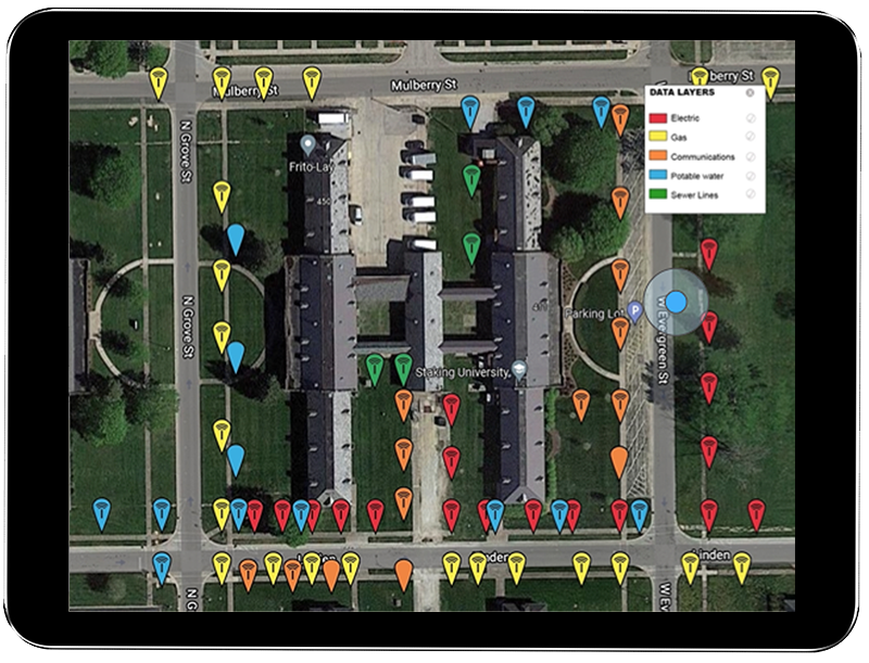
RFID markers of all utilities displayed in GIS
Gas
Electric
Telecom
Potable Water
Sewer
Periodically, the markers were located again by following a simple process – follow the GIS map to the area of a buried marker, scan it through the ground using the RFID reader (which displays and loads the RFID tag), then update that specific record via the InfraMarker mobile app.
In 2022, a thorough review of every marker was conducted and 93% of 174 buried RFID markers were located after seven years in the ground and 97.5% of those produced a successful RFID read.
This study offers a perfect basis to estimate the cost savings for locating and managing a range of utilities.
The average cost per utility strike is $4,000[2].
Assuming one utility strike per year per utility (5 utilities) x 7 (years), the result is 35 utility strikes.
Multiply that by $4,000 and the cost is $140,000.
The cost of the InfraMarker system (174 tags) $3,480 + software (7 years at $2,500/year = 17,500, making a total investment of $20,980.
$140,000 - $20,980 = 119,020
93% of utilities were located, which means $110,688 in utility strikes were prevented.
InfraMarker installation and one year cost is negligible compared to the potential savings resulting from efficient and accurate management of infrastructure assets. Safety is also enhanced due to more accurate asset locating and identification, preventing costly and dangerous utility strikes.
Additional benefits delivered:
One or more utilities can be managed and tracked within one commonly used GIS platform.
Data can be shared within and between organizations or can be controlled to prevent sharing.
InfraMarker’s cloud provides auditable tracking of an organization’s RFID facility activity.
Long-lasting solution - Passive RFID markers continue to connect to software over time, no matter how that software is modified and improved. More and more data can be added to each point, including video, sketches, photos and files – whatever information each organization requires.
Summary
The Common Ground Alliance[3] states that each year, $30 billion in costs are associated with utility strikes. Increased construction spending has consistently proven to correlate with an increase in damage. Anticipated funding from the Infrastructure Investment and Jobs Act is predicted to stress an already inundated damage prevention system[4].
Using RFID/GIS in conjunction with Subsurface Utility Engineering (SUE) amplifies savings and efficiency. The results of a range of DOT studies show that for every dollar spent on SUE, $11.39 in savings are generated[5] by avoiding expensive construction delays and costly utility strikes. Now is the time to create a lasting, accurate picture of subsurface infrastructure that can continue to deliver savings and safety now and in the future.
References:
[1] Technology Advancements & Gaps in Underground Safety Volume 5. © 2022 Common Ground Alliance
[4] DIRT Annual Report for 2021 © 2022 Common Ground Alliance

BERNTSEN ENHANCES THE CAPABILITY OF THE INFRAMARKER MOBILE APP
Berntsen International, maker of InfraMarker® Connected RFID™, announces a new release of the InfraMarker Mobile App, the field data collection component of the popular InfraMarker Connected RFID solution. RFID (Radio Frequency Identification) is a foundational, scalable technology that can link physical assets directly to their digital twin. InfraMarker uses the power of RFID to locate infrastructure assets faster and more accurately, provide field crews with instant access to asset information, and streamline inspection and maintenance workflows.
VERSION 2 RELEASED – NOW AVAILABLE IN THE APP STORE OR GOOGLE PLAY
MADISON, Wisc. Nov 3, 2021 – Berntsen International, maker of InfraMarker® Connected RFID™, announces a new release of the InfraMarker Mobile App, the field data collection component of the popular InfraMarker Connected RFID solution. RFID (Radio Frequency Identification) is a foundational, scalable technology that can link physical assets directly to their digital twin. InfraMarker uses the power of RFID to locate infrastructure assets faster and more accurately, provide field crews with instant access to asset information, and streamline inspection and maintenance workflows.
“This new Version 2 mobile app extends InfraMarker’s lead in using RFID to deliver accurate, field-verified asset management data,” said Mike Klonsinski, president of Berntsen International. “Connected RFID is the future of infrastructure asset management, and the InfraMarker approach of tying field assets directly to their records in the GIS-based Asset Management Software means real-time access to accurate data. This capability is especially important today, when organizations need better ways to track and manage all asset types, from gas lines to stormwater assets to telecom. Good decisions are based on good data, and InfraMarker delivers – in the field and in the office.”
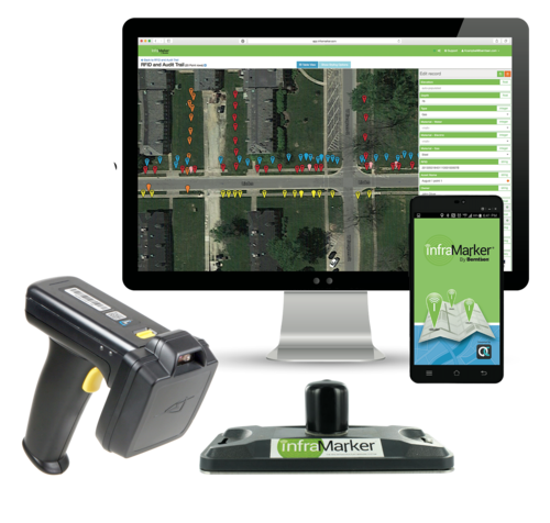
The InfraMarker Connected RFID solution consists of four integrated components:
InfraMarker RFID Markers – These rugged RFID tags come in a range of sizes and styles to suit any application. Whether used above ground or below the surface, these tags deliver connected asset information without requiring a power source.
RFID Reader – Several off the shelf types of RFID readers are certified for use with the InfraMarker solution.
InfraMarker Mobile App – Designed for intuitive user experience, this app is used in the field to connect the RFID tag data to its specific record in the Data Management System.
InfraMarker Asset Management Software – InfraMarker’s administrative interface delivers the power to view and manage field assets from the office in real time.
From creating data collection smart forms to sharing essential asset data, InfraMarker accurately manages any type of asset -- anywhere.
The newly-released Version 2 InfraMarker App adds additional capability for a user-friendly workflow. Contact us at info@inframarker.com.
About Berntsen International, Inc. and its InfraMarker® Solution:
As an infrastructure marking company founded in 1972, Berntsen has been developing smart marking products for more than 20 years. Its patented InfraMarker® Connected RFID™ solution combines the durability and precision of Berntsen marking products with a unique application of RFID technology specifically developed to connect physical markers with digital records.

RFID Crazy (xyHt) March 2019
Imagine if all public works engineers and utility company crew chiefs were equipped with a mobile device that could easily and accurately identify every piece of infrastructure underground and above ground—every gas valve, every water main or service line, every fiber optic cable, every transformer, and every light pole—and surveyors could use the same device to locate every survey marker.
Ten percent of all underground utility damage events are due to visible but incorrect markings. What if all public works engineers and utility company crew chiefs were equipped with a mobile device that could easily and accurately identify every piece of underground and above-ground infrastructure?

Innovative At Heart
MADISON, Wis.—Berntsen International, a leader in infrastructure marking systems designed for a connected world, is a finalist in the 2017 Wisconsin Innovation Awards.
The Wisconsin Innovation Awards celebrate and inspire innovation by highlighting the development of groundbreaking ideas. Berntsen’s InfraMarker solution is one of 233 products, businesses and services nominated across the state.
Berntsen International named a finalist in Wisconsin Innovation Awards
MADISON, Wis.—Berntsen International, a leader in infrastructure marking systems designed for a connected world, is a finalist in the 2017 Wisconsin Innovation Awards.
The Wisconsin Innovation Awards celebrate and inspire innovation by highlighting the development of groundbreaking ideas. Berntsen’s InfraMarker solution is one of 233 products, businesses and services nominated across the state.
“We’re excited to be named a finalist and be part of this impressive group of Wisconsin companies,” said Mike Klonsinski, president of Berntsen, a family-owned small business founded in 1972. “We’re especially proud to be a traditional manufacturer that has evolved to create products for the Internet of Things world.”
— Mike Klonsinski
For nearly five decades, Berntsen has produced high-quality survey markers used in the utility and construction industries and national parks and monuments. In recent years the company identified the need to create a “smart” marker that could “communicate” from below the earth’s surface. After extensive research, testing and collaboration with private and public partners, the company patented and launched InfraMarker as the centerpiece of its new line of connected marking products.
InfraMarker uses a mobile app, GIS software, and RFID-enabled markers and readers to precisely locate, monitor and manage underground assets such as pipelines and water mains. InfraMarker’s digital platform relays data, photos, videos and other documentation in real-time via the cloud to company enterprise systems. This allows utilities, municipalities and other asset owners to capitalize on the data-rich benefits of IoT to analyze trends, streamline operations and make better decisions. In addition, data-driven asset management promotes greater transparency, easy data sharing and audit trails to enhance regulatory compliance.
Once installed on underground pipelines, InfraMarker’s RFID precision locating improves public safety by solving the decades-old problem of knowing exactly where underground pipelines are buried. On average an underground utility line is damaged every two minutes, sometimes with tragic consequences.
Thirty Wisconsin Innovation Award finalists were determined by a panel of 23 statewide industry experts. Winners will be announced Oct. 4, 2017 at an awards ceremony in Madison.
About Berntsen International, Inc.
Madison, Wisconsin-based Berntsen International, Inc. manufactures boundary and survey markers and is an innovation leader in smart marking solutions designed for a connected world. Since its founding in 1972, Berntsen has been marking global infrastructure and boundaries with a high-quality product line of 1,000 markers located in more than 100 countries. Berntsen’s patented InfraMarker solution, which uses a mobile app, GIS software, and RFID-enabled markers and readers to locate and manage underground assets, recently received the Geospatial World Excellence Award for Technology Innovation and the RFID Journal Award for Best Use of RFID to Enhance a Product or Service. For more information, visit www.BerntsenInternational.com.
Media Contact:
Linda Abbott
info@inframarker.com
608-249-8549