GIS + RFID = SUE Enhancement
Subsurface Utility Engineering (SUE) that leverages Geographic Information Systems (GIS) and Radio Frequency Identification (RFID) deliver substantial benefits in the management and protection of underground assets.
Both GIS and RFID are rapidly-growing, powerful technologies that are used across a wide spectrum of industries, from manufacturing to agriculture to SUE.

When used together, GIS and RFID deliver accurate, verified information about any type of asset – above or below ground. This is particularly compelling for re-locating buried assets before excavation. It’s essential to know what’s below, and scanning the RFID buried asset tag provides authentication of its data in GIS.
RFID is a simple and durable technology, ideal for pairing with GIS. RFID tags consist of a microchip and antenna. Basic information, such as the asset’s location, identity and owner are written to the tag. When scanned, this data connects to GIS, accessing the correct data and launching maintenance/inspection surveys.
Today, a growing number of agencies and municipalities use Esri’s ArcGIS for Subsurface Utility Engineering. Esri’s popular data collection apps integrate with InfraMarker RFID, making accessible to any organization that uses ArcGIS and Field Maps or Survey123. Recently, Esri announced a June Survey123 update that includes a more seamless integration with InfraMarker RFID.
According to Esri:
“With InfraMarker, a field user can scan a RFID tag and instantly launch the related inspection form in Survey123 … faster and without errors in asset misidentification. You can also use InfraMarker for Survey123 to write information to a new RFID tag and easily associate the unique identifier in your ArcGIS system of record.
The technology is increasingly used in infrastructure asset management thanks to its durability in the field, flexibility to serve as a unique ID on almost any asset, and ability to be read from distance or through mediums such as walls, ground, or concrete.”
SUE and RFID for Infrastructure
This technology is on target for use in all kinds of infrastructure projects that rely on Subsurface Utility Engineering.
The 2022 CGA Technology Report notes that applying emerging mapping/GIS technologies in project design and SUE would reduce potholing and associated expenses involved in locating buried utilities.[1] This report delivers a snapshot of how technology is used specifically to prevent damage during excavation. RFID is included for facility installation and locating, and stated that “a comprehensive national GIS map of buried infrastructure would make the locating process drastically more efficient and accurate, and identify abandoned facilities.”
A recent longitudinal study has demonstrated the long-term feasibility of combining RFID and GIS.
Staking University in Manteno, IL was the site for a perfect test case of using this technology in a residential setting. This campus encompasses more than 20 acres of live and abandoned utilities offering real-world conditions for field testing utility products.
Because RFID markers are passive, they can simply be scanned and connected to GIS for verification – even years later.
In 2015, 174 RFID markers were placed on or near utilities. Utilities marked were:
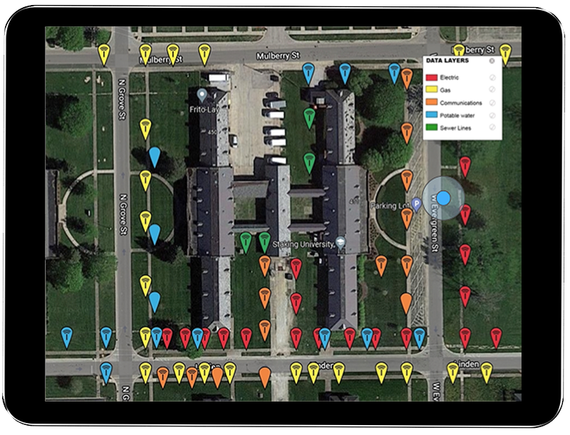
RFID markers of all utilities displayed in GIS
Gas
Electric
Telecom
Potable Water
Sewer
Periodically, the markers were located again by following a simple process – follow the GIS map to the area of a buried marker, scan it through the ground using the RFID reader (which displays and loads the RFID tag), then update that specific record via the InfraMarker mobile app.
In 2022, a thorough review of every marker was conducted and 93% of 174 buried RFID markers were located after seven years in the ground and 97.5% of those produced a successful RFID read.
This study offers a perfect basis to estimate the cost savings for locating and managing a range of utilities.
The average cost per utility strike is $4,000[2].
Assuming one utility strike per year per utility (5 utilities) x 7 (years), the result is 35 utility strikes.
Multiply that by $4,000 and the cost is $140,000.
The cost of the InfraMarker system (174 tags) $3,480 + software (7 years at $2,500/year = 17,500, making a total investment of $20,980.
$140,000 - $20,980 = 119,020
93% of utilities were located, which means $110,688 in utility strikes were prevented.
InfraMarker installation and one year cost is negligible compared to the potential savings resulting from efficient and accurate management of infrastructure assets. Safety is also enhanced due to more accurate asset locating and identification, preventing costly and dangerous utility strikes.
Additional benefits delivered:
One or more utilities can be managed and tracked within one commonly used GIS platform.
Data can be shared within and between organizations or can be controlled to prevent sharing.
InfraMarker’s cloud provides auditable tracking of an organization’s RFID facility activity.
Long-lasting solution - Passive RFID markers continue to connect to software over time, no matter how that software is modified and improved. More and more data can be added to each point, including video, sketches, photos and files – whatever information each organization requires.
Summary
The Common Ground Alliance[3] states that each year, $30 billion in costs are associated with utility strikes. Increased construction spending has consistently proven to correlate with an increase in damage. Anticipated funding from the Infrastructure Investment and Jobs Act is predicted to stress an already inundated damage prevention system[4].
Using RFID/GIS in conjunction with Subsurface Utility Engineering (SUE) amplifies savings and efficiency. The results of a range of DOT studies show that for every dollar spent on SUE, $11.39 in savings are generated[5] by avoiding expensive construction delays and costly utility strikes. Now is the time to create a lasting, accurate picture of subsurface infrastructure that can continue to deliver savings and safety now and in the future.
References:
[1] Technology Advancements & Gaps in Underground Safety Volume 5. © 2022 Common Ground Alliance
[4] DIRT Annual Report for 2021 © 2022 Common Ground Alliance