
It’s National Engineers Week!
Most engineers would argue that it’s always engineers week, but this week is the “official” week to highlight the stunning array of engineering accomplishments and types of engineering that make our lives easier in every way.
Most engineers would argue that it’s always engineers week, but this week is the “official” week to highlight the stunning array of engineering accomplishments and types of engineering that make our lives easier in every way.
The recent focus on infrastructure has helped bring engineering to the forefront. The tremendous work engineers have done to design and built our bridges, roads, airports is obvious for all to see. And everyone can see what happens when structures outlive their projected lifespan, not maintained properly or not replaced on schedule.

Dr. Snow’s waterworks map of 1846 from the UCLA Epidemiology John Snow Site.
However, many engineers are focused on the infrastructure we don’t see – the underground infrastructure, such as stormwater systems, buried telecom cables, gas and other buried pipelines. It’s a different world below ground where all these systems exist, conflict, age and require maintenance. In the past few years, enormous strides have been made to identify and map underground utilities and structures using new engineering approaches, as well as Geographic Information Systems (GIS).
GIS is a technology that uses maps to visualize data. GIS first appeared as a map created by Dr. John Snow in 1854. He plotted all the cholera outbreak locations in London, along with roads, property boundaries and water lines. His map revealed that cholera outbreaks were clustered around a water pump, challenging the existing notion that cholera was spread through the air. Along with creating one of the first uses of Geographic Information, Dr. Snow also is credited with starting the field of Epidemiology.
MAPPING + COMPUTERS
Mapping and analysis continued to be done on paper until the 1960s. Then, along came Roger. Roger Tomlinson was a British-trained geographer and geologist who worked for the Government of Canada and for an Ottowa-based aerial survey company. He figured out a way to computerize the process. While working on a project to identify the best location for a tree plantation in Kenya, Tomlinson partnered with IBM to find a way to bridge the gap between geographic data and computer services. This initiative was eventually extended to create a national mapping system that created maps of Canada’s commercially-leveraged land used for agriculture, forestry, wildlife and recreation. It was during this project that Tomlinson created the term “Geographic Information Systems” to describe his synthesis of computer mapping with capabilities for overlay, measurement, and digitizing.
SMART CITIES

Today, GIS, ground-penetrating radar and other emerging technologies are helping utilities and cities build a digital map that captures the exact location of utilities. This is a major part of any “Smart City” initiative.
Unfortunately, a disconnect between the real world and the digital world persists, despite all the technology. For example, a growing number of municipalities are using GIS systems to manage the inspection and maintenance of various types of utilities, including stormwater assets. The stormwater manager will use the GIS to schedule inspections, assuming that the data in the GIS is accurate. When the field crew arrives at the scheduled location, they often discover that the data in the GIS simply doesn’t match what they actually see when they arrive. The assets may not be where they are supposed to be, including above-ground assets such as manholes and catch basins. This confusion and uncertainty waste a lot of time which can leading to errors.
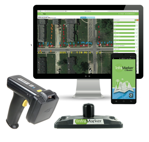
CONNECTED RFID

InfraMarker Connected RFID
Fortunately, there is now a technological solution that ties the digital world directly to the real world using RFID, the fastest-growing asset ID technology in the world. Engineers at Berntsen International leverage both GIS and RFID to create a simple approach to resolve the digital/reality disconnect. RFID tags, each with its unique ID, are placed on any type of asset. Then the asset ID is connected to its specific record in GIS. A quick scan of the asset will load any applicable forms for the field staff to fill out. This connection means that assets (even underground assets) are correctly identified, and the record is accessible where it counts – in the field for updating and in the office for scheduling.
This simple approach, called InfraMarker Connected RFID, has broad implications for infrastructure asset management. It improves asset locating and identification, speeds inspection and maintenance workflows, reduces errors and supports compliance requirements.
Additionally, Connected RFID provides an important safety mechanism for the management of buried assets. Everyone has seen news stories about gas lines, telecom cables or water mains being accidentally struck during construction. Sometimes these accidents involve injury and/or loss of life, and they almost always result in property damage and loss of service. In 2019, an estimate of the annual societal costs from damages to buried utilities was approximately $30 billion.
If buried assets were marked with RFID, they could be quickly located and identified with a simple RFID scan. Important information about other nearby buried utilities can be easily added to an asset record in GIS, making that information accessible and shareable across utilities.
Thanks to engineers, this technology is available today, making infrastructure asset management more efficient, more useable, and safer.

BERNTSEN ENHANCES THE CAPABILITY OF THE INFRAMARKER MOBILE APP
Berntsen International, maker of InfraMarker® Connected RFID™, announces a new release of the InfraMarker Mobile App, the field data collection component of the popular InfraMarker Connected RFID solution. RFID (Radio Frequency Identification) is a foundational, scalable technology that can link physical assets directly to their digital twin. InfraMarker uses the power of RFID to locate infrastructure assets faster and more accurately, provide field crews with instant access to asset information, and streamline inspection and maintenance workflows.
VERSION 2 RELEASED – NOW AVAILABLE IN THE APP STORE OR GOOGLE PLAY
MADISON, Wisc. Nov 3, 2021 – Berntsen International, maker of InfraMarker® Connected RFID™, announces a new release of the InfraMarker Mobile App, the field data collection component of the popular InfraMarker Connected RFID solution. RFID (Radio Frequency Identification) is a foundational, scalable technology that can link physical assets directly to their digital twin. InfraMarker uses the power of RFID to locate infrastructure assets faster and more accurately, provide field crews with instant access to asset information, and streamline inspection and maintenance workflows.
“This new Version 2 mobile app extends InfraMarker’s lead in using RFID to deliver accurate, field-verified asset management data,” said Mike Klonsinski, president of Berntsen International. “Connected RFID is the future of infrastructure asset management, and the InfraMarker approach of tying field assets directly to their records in the GIS-based Asset Management Software means real-time access to accurate data. This capability is especially important today, when organizations need better ways to track and manage all asset types, from gas lines to stormwater assets to telecom. Good decisions are based on good data, and InfraMarker delivers – in the field and in the office.”
The InfraMarker Connected RFID solution consists of four integrated components:
InfraMarker RFID Markers – These rugged RFID tags come in a range of sizes and styles to suit any application. Whether used above ground or below the surface, these tags deliver connected asset information without requiring a power source.
RFID Reader – Several off the shelf types of RFID readers are certified for use with the InfraMarker solution.
InfraMarker Mobile App – Designed for intuitive user experience, this app is used in the field to connect the RFID tag data to its specific record in the Data Management System.
InfraMarker Asset Management Software – InfraMarker’s administrative interface delivers the power to view and manage field assets from the office in real time.
From creating data collection smart forms to sharing essential asset data, InfraMarker accurately manages any type of asset -- anywhere.
The newly-released Version 2 InfraMarker App adds additional capability for a user-friendly workflow. Contact us at info@inframarker.com.
About Berntsen International, Inc. and its InfraMarker® Solution:
As an infrastructure marking company founded in 1972, Berntsen has been developing smart marking products for more than 20 years. Its patented InfraMarker® Connected RFID™ solution combines the durability and precision of Berntsen marking products with a unique application of RFID technology specifically developed to connect physical markers with digital records.

SURVEYING THE FUTURE WITH RFID
Pretend we are visiting the site of an ALTA/ACSM survey 50 years from now. This is a site where we previously set the monuments using Berntsen RFID-enabled DEEP1 magnets. . .
Paul Mabry, editor of California Surveyor, offers a scenario of how RFID could be used in the the future. Berntsen’s Mike Klonsinski share how RFID makes that future possible - today.

Pretend we are visiting the site of an ALTA/ACSM survey 50 years from now. This is a site where we previously set the monuments using Berntsen RFID-enabled DEEP1 magnets. . .
Next, we deploy our drone outfitted with GNSS, a magnetic locator and RFID transceiver to hover over each monument coordinates to confirm the existing monuments and search for any missing monuments. . .
RFID Expedites Recovery
Disasters run the gamut, from environmental factors to cyber-threats to aging infrastructure. Keep in mind America receives an overall grade of D+ on the American Society of Civil Engineers Infrastructure Report Card, with the categories of drinking water, energy, and wastewater receiving a D or D+ mark.
Disasters Underscore Critical Need for Connected Utility Infrastructure
Digital Mapping Expedites Disaster Recovery, Has the Potential to Save Lives
On Sept. 14, 2018, Hurricane Florence slammed into the Carolinas, bringing with her powerful winds, torrential rains and the potential to wreak catastrophic destruction. Though Florence was downgraded to a Category 1 storm as it moved over land, its high winds and rain toppled trees, triggered massive flooding and caused power transformers to explode like fireworks, leaving hundreds of thousands of people without power. More than 40 people have died as a result of the storm and flooding.
A day earlier, 800 miles up the East Coast, another disaster had occurred. Dozens of rapid-fire gas explosions caused 70 home fires and one fatality in what one official described as “Armageddon.” Entire neighborhoods north of Boston were forced to evacuate, and firefighters and crews scrambled to fight the flames and shut off the gas and electricity to the affected areas. The fires were caused when too much natural gas was pumped into a section of pipe and then leaked into homes.

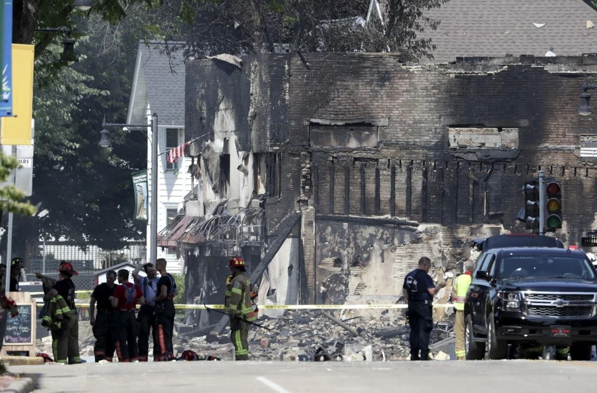
These disasters—and others including the California wildfires and Hurricanes Harvey and Irma—are a cogent reminder of the critical need to upgrade and digitize our utility infrastructure. This is especially relevant for all of us at Berntsen who live and work in Wisconsin, where a massive explosion destroyed a city block in downtown Sun Prairie and killed a volunteer firefighter in July. The fact that we design equipment that might have prevented this disaster and so many others saddens us, and this tragedy has deeply affected our employees.
Disasters on the Rise

Disasters run the gamut, from environmental factors to cyber-threats to aging infrastructure. Keep in mind America receives an overall grade of D+ on the American Society of Civil Engineers Infrastructure Report Card, with the categories of drinking water, energy, and wastewater receiving a D or D+ mark.
A 2017 report prepared by Johns Hopkins University notes that the U.S. insurance industry has identified a $20 to $55 billion annual financial loss from power outages caused by flooding, hurricanes, and extreme temperatures. A combination of “higher average global temperatures, more destructive storms, and hurricanes, and increased risk of wildfire will ultimately worsen risk exposure for utilities,” the report states.
Many public and private utilities have state-of-the-art asset management systems to tackle the challenge of disasters, but the widespread deployment of these systems is lacking in much of the country, putting communities and citizens at greater risk. Over time, failure to adopt digital technologies will lead to slower disaster recovery times, potentially greater loss of life and bigger financial losses to business and the public.
“Over time, failure to adopt digital technologies will lead to slower disaster recovery times, potentially greater loss of life and bigger financial losses to business and the public. ”
The good news is digital transformation is coming to the utility industry and innovative technologies already exist to improve disaster planning, response, recovery, and underground asset management.
Connected Marking and Digital Mapping Are a Game Changer

Disasters such as storms, wildfires, explosions, and earthquakes often require gas, water, electric and telecommunications companies to quickly identify, locate and access underground utility assets.
In August 2017, a major fiber network outage in Atlantic Canada shut down cellphone and Internet service, closed some bank branches and delayed flights at multiple airports. The problem was caused when two fiber optics lines were cut during construction work.
The ability to quickly locate and repair underground utility assets is often hampered by outdated maps and inaccurate data. During a disaster, these delays can be devastating and deadly.
Connected marking solutions for utility infrastructure such as the InfraMarker® system from Berntsen International are a game changer for asset management and extremely helpful in disaster recovery. In a disaster, utility crews can use the InfraMarker mobile app and digital mapping software to quickly find the exact location of a gas pipeline shut-off valve to prevent an explosion. It’s that powerful.
This unique combination of RFID, mobile app and digital mapping software significantly expedites underground utility locating.
InfraMarker is a secure and easy way to collect and relay essential utility asset data. From there, the data can be accessed on smartphones and by popular GIS systems such as ArcGIS. Going forward, connected marking solutions will play an integral role in Smart City utility asset management.

In the past, the most important part of infrastructure management was to locate the asset. Today, infrastructure management requirements are greater and more complex. Location and other relevant data need to be available to multiple users faster—ideally in real-time—and to be integrated with GIS, ERP, workflow management and regulatory/compliance systems.
RFID is a highly effective tool for precision locating. But the key advantage of connected marking is the ability to collect, store and share asset data via the cloud. This next-gen innovation delivers exceptional benefits and ROI to utility asset managers, emergency responders, and citizens, and also has the potential to save lives.

RFID Expedities Recovery
Disasters run the gamut, from environmental factors to cyber-threats to aging infrastructure. Keep in mind America receives an overall grade of D+ on the American Society of Civil Engineers Infrastructure Report Card, with the categories of drinking water, energy, and wastewater receiving a D or D+ mark.
Disasters underscore critical need for connected utility infrastructure
Digital mapping expedites disaster recovery, has the potential to save lives
On Sept. 14, 2018, Hurricane Florence slammed into the Carolinas, bringing with her powerful winds, torrential rains and the potential to wreak catastrophic destruction. Though Florence was downgraded to a Category 1 storm as it moved over land, its high winds and rain toppled trees, triggered massive flooding and caused power transformers to explode like fireworks, leaving hundreds of thousands of people without power. More than 40 people have died as a result of the storm and flooding.
A day earlier, 800 miles up the East Coast, another disaster had occurred. Dozens of rapid-fire gas explosions caused 70 home fires and one fatality in what one official described as “Armageddon.” Entire neighborhoods north of Boston were forced to evacuate, and firefighters and crews scrambled to fight the flames and shut off the gas and electricity to the affected areas. The fires were caused when too much natural gas was pumped into a section of pipe and then leaked into homes.
These disasters—and others including the California wildfires and Hurricanes Harvey and Irma—are a cogent reminder of the critical need to upgrade and digitize our utility infrastructure. This is especially relevant for all of us at Berntsen who live and work in Wisconsin, where a massive explosion destroyed a city block in downtown Sun Prairie and killed a volunteer firefighter in July. The fact that we design equipment that might have prevented this disaster and so many others saddens us, and this tragedy has deeply affected our employees.
Disasters on the rise
Disasters run the gamut, from environmental factors to cyber-threats to aging infrastructure. Keep in mind America receives an overall grade of D+ on the American Society of Civil Engineers Infrastructure Report Card, with the categories of drinking water, energy, and wastewater receiving a D or D+ mark.
A 2017 report prepared by Johns Hopkins University notes that the U.S. insurance industry has identified a $20 to $55 billion annual financial loss from power outages caused by flooding, hurricanes, and extreme temperatures. A combination of “higher average global temperatures, more destructive storms, and hurricanes, and increased risk of wildfire will ultimately worsen risk exposure for utilities,” the report states.
Many public and private utilities have state-of-the-art asset management systems to tackle the challenge of disasters, but the widespread deployment of these systems is lacking in much of the country, putting communities and citizens at greater risk. Over time, failure to adopt digital technologies will lead to slower disaster recovery times, potentially greater loss of life and bigger financial losses to business and the public.
The good news is digital transformation is coming to the utility industry and innovative technologies already exist to improve disaster planning, response, recovery, and underground asset management.
Connected marking and digital mapping are a game changer
Disasters such as storms, wildfires, explosions, and earthquakes often require gas, water, electric and telecommunications companies to quickly identify, locate and access underground utility assets.
In August 2017, a major fiber network outage in Atlantic Canada shut down cellphone and Internet service, closed some bank branches and delayed flights at multiple airports. The problem was caused when two fiber optics lines were cut during construction work.
The ability to quickly locate and repair underground utility assets is often hampered by outdated maps and inaccurate data. During a disaster, these delays can be devastating and deadly.
Connected marking solutions for utility infrastructure such as the InfraMarker® system from Berntsen International are a game changer for asset management and extremely helpful in disaster recovery. In a disaster, utility crews can use the InfraMarker mobile app and digital mapping software to quickly find the exact location of a gas pipeline shut-off valve to prevent an explosion. It’s that powerful.
This unique combination of RFID, mobile app and digital mapping software significantly expedites underground utility locating.
InfraMarker is a secure and easy way to collect and relay essential utility asset data. From there, the data can be accessed on smartphones and by popular GIS systems such as ArcGIS. Going forward, connected marking solutions will play an integral role in Smart City utility asset management.
In the past, the most important part of infrastructure management was to locate the asset. Today, infrastructure management requirements are greater and more complex. Location and other relevant data need to be available to multiple users faster—ideally in real-time—and to be integrated with GIS, ERP, workflow management and regulatory/compliance systems.
RFID is a highly effective tool for precision locating. But the key advantage of connected marking is the ability to collect, store and share asset data via the cloud. This next-gen innovation delivers exceptional benefits and ROI to utility asset managers, emergency responders, and citizens, and also has the potential to save lives.

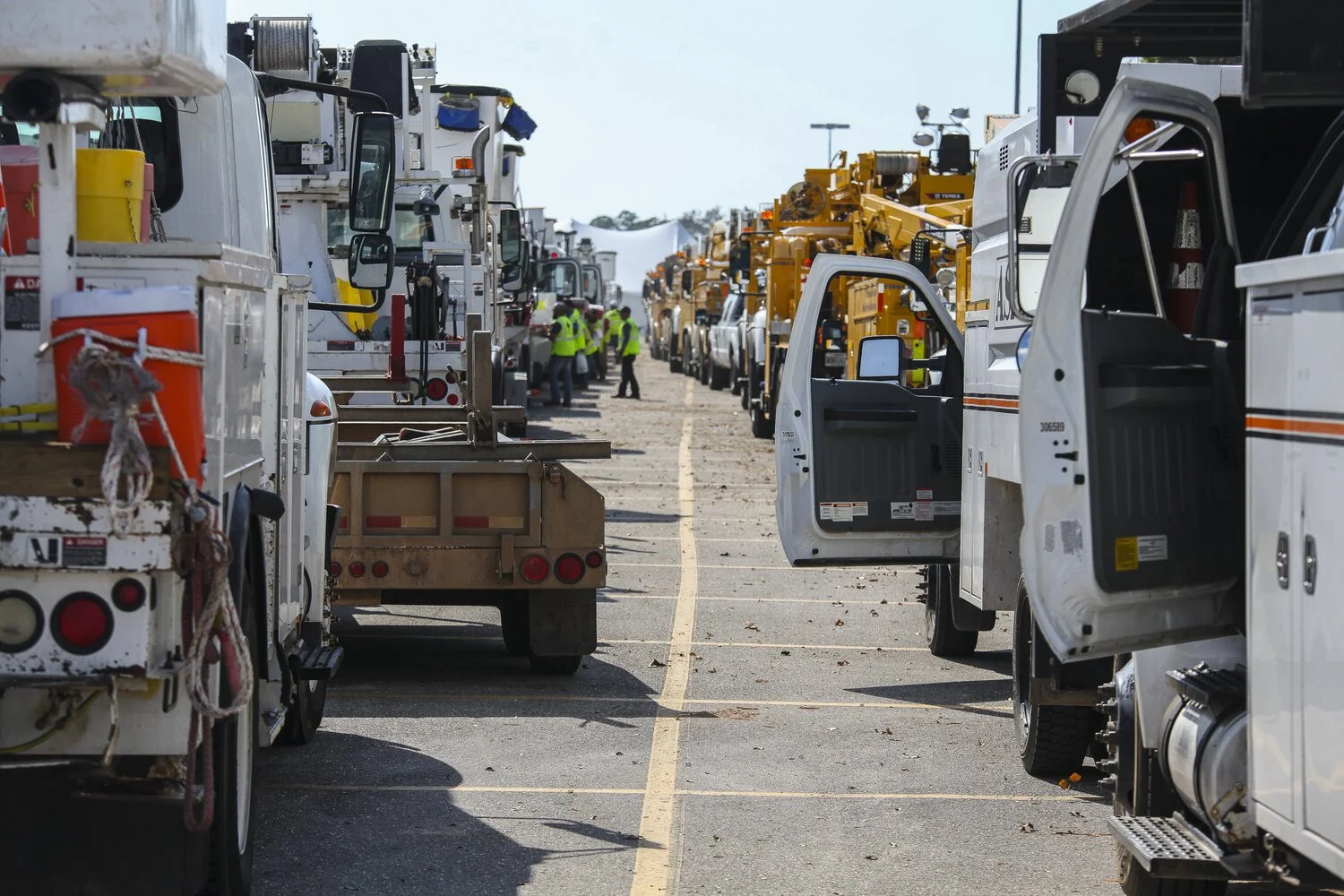
Image credit: FEMA - Utility Trucks and Crews Line up To Help

Image credit: Wisconsin State Journal
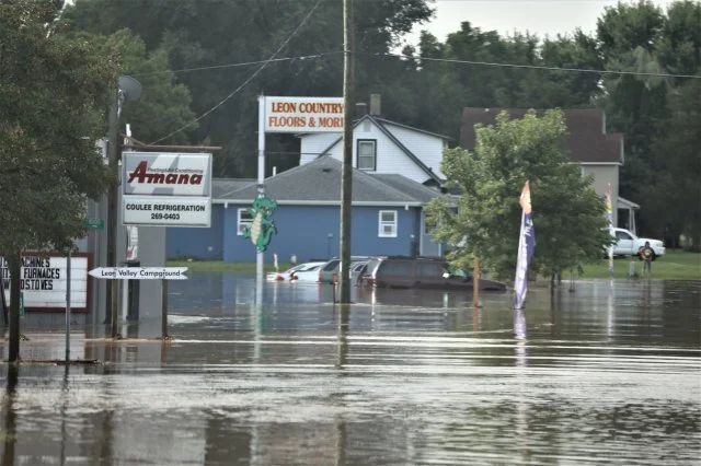
Image credit: US Army
Over time, failure to adopt digital technologies will lead to slower disaster recovery times, potentially greater loss of life and bigger financial losses to business and the public.