THE CRUCIAL FIRST STEP IN FIXING AMERICA'S AGING UNDERGROUND UTILITY INFRASTRUCTURE

Projected growth
By 2050, the US population is projected to grow by 30 percent.
That’s an additional 100 million people putting stress and strain on a already overworked public infrastructure made up of roads, bridges, tunnels and a myriad of other vital systems.
Over the next 20 years, upgrades to the nation’s water system alone are expected to cost three to five trillion dollars. Yet appropriations to replace critical infrastructure continually fall short. Municipalities and utility companies are under enormous pressure to make existing assets more efficient.
Fixing this problem will not be cheap or easy.
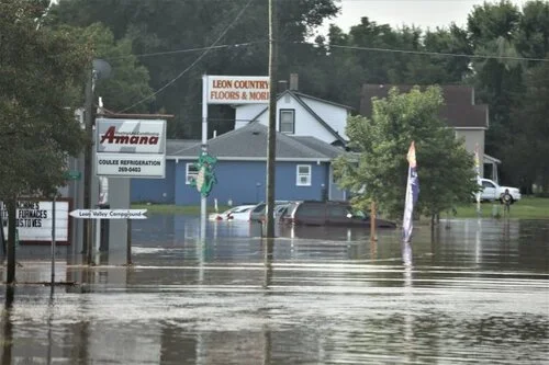
While crumbling roadways, cracked bridges and deteriorating railways grab national attention, the country’s vast, hidden infrastructure suffers from the same level of neglect and under-investment. Specifically, the system that carries our drinking water, sewage and stormwater is critically neglected.
The question is, how can utilities and municipalities best manage existing assets?
The answer is:
Develop a complete inventory of assets
Monitor assets for problems and investigate causes
Assess the life-cycle of materials and the cost of their procurement and replacement
Rehabilitate underground asset networks
Prioritize the selection, design and timing of replacing aging assets.
RFID and the future of underground asset management
Part of what makes the problems of aging underground infrastructure so difficult is the lack of even basic data on asset type, location and condition. Radio Frequency Identification (RFID) is proving to be a valuable tool that links physical locations of assets with a GIS system. This means that asset manager get accurate, verified information about each physical asset through commonly used asset management systems that leverage GIS, such as Cityworks.
Updating a record in the InfraMarker mobile app.
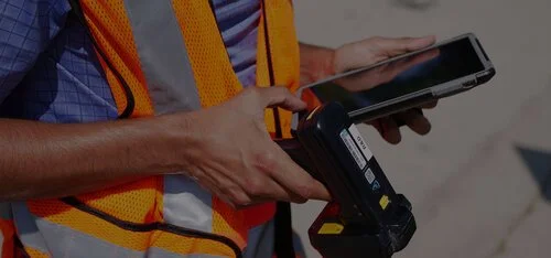
Updating a record in the InfraMarker mobile app.
This information is used to efficiently manage inspection and repair activities. How does it work? RFID tags are affixed to an asset, that tag is accessed using a simple mobile app that stores its location and unique identifier. Any amount of information can be added to that record, such as inspection logs and so forth. This data is then available to the GIS where it can be accessed by managers or any field personnel who need it.
For example, catch basins require inspection on a regular basis; oftentimes an area of a few hundred square feet can have dozens of catch basins. Crews often waste a large amount of time trying to figure out which basin they are inspecting vs what they are scheduled to inspect. The GIS and GPS can direct workers to the general area but lack the precision to verify location. However, when an asset is tagged with an InfraMarker RFID tag, field workers can simply scan the tag, and access its record in a mobile app. No guesswork is involved, and an auditable track is automatically generated, meeting regulatory requirements.
Want to learn more? Arrange a demo today!