INVESTMENTS IN SUBSURFACE UTILITY MAPPING TECHNOLOGY MEAN BIG SAVINGS FOR CITIES
Construction intended to improve public infrastructure is the most costly and involved public works undertakings by government and contracting firms.
It’s surprising that many of the costs associated with large-scale construction projects stem from either relocating underground utilities or simply designing around them so they don’t need to be moved.
These costs could be avoided if accurate information about the nature and location of underground utilities were available. Unfortunately, accurate data is not available. In many cases missing or inaccurate buried infrastructure information increases the risk of cost and schedule overruns – compounding the expense of major projects.
This lack of buried asset information is estimated to cost the U.S. about $50 billion annually. Traditional mapping and marking techniques simply don’t provide the accuracy required for large scale construction projects.
THIS LACK OF BURIED ASSET INFORMATION IS ESTIMATED TO COST THE U.S. ABOUT $50 BILLION ANNUALLY.
Traditional mapping and marking techniques simply don’t provide the accuracy required for large scale construction projects.

THIS LACK OF BURIED ASSET INFORMATION IS ESTIMATED TO COST THE U.S. ABOUT $50 BILLION ANNUALLY.
Studies show that better mapping systems translate to significant savings
According to a 1999 Purdue University survey sponsored by the US Department of Transportation, a total of $4.62 was saved for every $1.00 spent when comprehensive underground utility location maps informed construction projects.
A 2004 study by the Ontario Sewer and Water main Contractors Association and the University of Toronto found that the average rate of return on every dollar spent to improve the visibility of subsurface utilities resulted in a savings of $3.41.
In 2010 study by the University of Toronto monitored nice large city and highway rebuilding projects found that accurate underground utility marking benefitted every project. Further, a positive ROI on $2.05 to $6.59 resulted from every dollar spent to improve underground utility mapping.
RFID is a cost-saving alternative
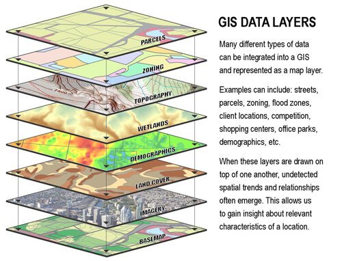
Today, many public works departments utilize GIS that can display the location of underground utilities. However, even with GIS-based asset management systems, precision may be difficult to come by. Most systems rely on GPS to find locations, which is only accurate within several feet – not good enough when locating underground gas lines, for instance.
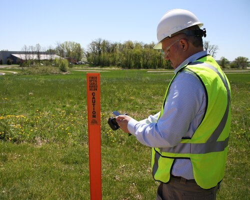
The best way to accurately find underground assets is to physically mark them – then find those markers before construction begins. Fortunately, a combination of proven, reliable technology is now available to streamline this process.
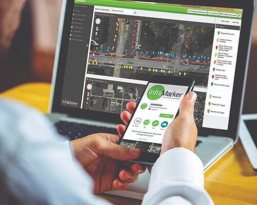
The InfraMarker® RFID-enabled asset management system leverages the unique marking ability of RFID connected to a mobile app that can quickly append data to each specific RFID marker. This data is connected to the GIS and provides a detailed, accurate map of each underground asset – information that can be audited, updated and tracked in the GIS.
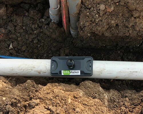
Each RFID-enabled marker is rugged, unique and passive which means that it can last as long as the infrastructure and will continue to provide specific asset information each time it is read.
This system provides the accuracy, location verification and comprehensive data that utilities can rely on for accurately mapping and managing both subsurface and above-ground infrastructure assets.
Just contact us to set up a demo to see how the simple, easy-to-use and setup InfraMarker system can save time, money and provide the data you need with the accuracy you require.